The RhB Engadin linie  

The Rhaetian capital Chur is a frequently taken starting point to enter the Rhaetian railroad network. About 400 km rail tracks develop the beautiful countryside.
For geographical details click on the area map left.

The Engadin line is located between Pontresina in the upper Engadin (altitude 1774 m) and Scuol - Tarasp, which is the eastern terminal station (altitude 1287 m). In Samedan the line to St. Moritz branches off, in Bever the Albula line starts

northwards and in Sagliains the new Vereina tunnel which was opened on 19. 11. 1999 also goes northwards. It's the shortest connection to Chur.

The Engadin line's length is about 57 km and the vertical difference is about 487 m. Especially the section between Cinuos-chel and Scuol - Tarasp presents a lot of interesting line buildings integrated into the difficult terrain.

In August 2002 I dedicated 2 days of my Switzerland stay to produce the following gallery regarding the Engadin line. Scroll down to see the preview images. Click on the photos and get the enlarged view.

Beside this gallery you may also visit my Rhaetian galleries about the Albula line, about the
Bernina line
, the celebration in Filisur, 100 years Albula and the Filisur - Thusis - Chur line.

  The Rhaetian railroad provides a lot of information for interested fans. Beside the standard timetable for 2.- Sfr one may get a graphical timetable of the whole RhB network (~ 15.- Sfr). At certain stations additionally the precise locomotive schedule for the next day may also be checked or even taken. All in all ideal conditions for planning railroad photographers...
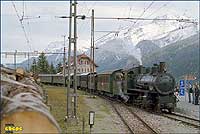
  On October 20th, 2002 a steam train with the G 4/5 108 and
all green carriages was set in operation at the Engadin. Because I stayed in Filisur the day before, I planned to visit
this train too. But because of my late crossing the Albula pass, the train had already reached the lunch stop position in Scuol when I arrived. (top of page)
  Therefore I could just take some station photographs, two of them you see here. Here in the lower Engadin the snow of the last days was already melted. At the upper Engadin close to
St. Moritz fine winter environment shots were possible this
day. But I was not there, unfortunately. As visible besides the G 4/5 108 also the Ge 6/6 414 is here (10/2002).
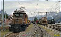
  The station Scuol - Tarasp is eastern terminal station of the Engadin line. The layout would allow a further line extension.
Of course such extension to the Austrian Landeck was
foreseen at the beginning. WW1 was the reason not to realize this plan (8/2002).
  In Scuol - Trasp equippment for freight handling is existing. Container cranes and other gadgets are visible. Due to the graphical time table several freight trains are dispatched here everyday (8/2002). (top of page)
  High above Ardez the former fortress tower Steinsberg is a landmark. The railway station is not far away from the city center. In Ardez there are still a lot of older buildings which present the typical and fine restored Engadin Sgraffito façades (8/2002).
  At 7:54 am, a regional stopping push pull combination stops at the Guarda station. Terminus will be Pontresina, which is at the same time starting point of the famous Bernina line. The station building is typical for this region (9/2004).  
  Close to Guarda the Val Tuoi viaduct crosses the waters of the La Clozza river. The building is about 111 m long and the main arch has about 50 m span. It's beautifully visible from the highway. History tells, that they used the scaffold works used at the Inn viaduct close to Cinuos - chel here for a second time (8/2002). (top of page)  
  At Susch the line crosses the Susasca river and valley. The mountain road via the Fuela pass to Davos also branches here. Ge 4/4 II with train crosses the Susasca river bridge (9/2004).  
  Close to Zernez the line crosses the Inn river on a frame work bridge. Here also the Ofen-pass road runs into the Engadin. Most of the compositions are push pull trains like visible on the image. The loco Ge 4/4 II on the bridge sided end pushes the train up the Engadin valley (8/2002).
  On the further way to Pontresina, the train passes this nice bridge. Starting here the line track partly performs really adventurous style through the river Inn gorge. The old station Carolina located in this region works unmanned today (8/2002). (top of page)
  This is a snap shot picture of a train passing the Val Verda viaduct. There was not enough time to set up the camera correctly. From this valley side it's hard to find a good view on the viaduct. Maybe one could find some better position at the opposite side of the valley. The 52 m long viaduct connects the both Brail tunnels in about 20 m above ground (8/2002).
  Between Zernez and Cinuos - chel there is some hiking trail existing which generally follows the rail tracks. This image of the Val Mela viaduct was taken from this hiking trail. In the back visible the opposite side of the Inn valley and in between the deep river gorge. It's one of my favourites (8/2002).
  Before the train reaches the Cinuos - chel station, the Inn river viaduct needs to be passed. This 7 arches building crosses the valley in about 50 m height. From here on the line uses the left river bank (8/2002). (top of page)
  Such compositions are running as regional trains between Pontresina and Scuol - Tarasp. Here and on most other RhB lines trains are running hourly. Here the line leaves a bit the gorge which makes the line construction a little easier (8/2002).
  Between the both stations Cinuos - chel and S - chanf the also famous Val Susauna viaduct is located. In the background the access road to the local camp ground is visible. The imposing building has 6 arches and a length of about 120 m (8/2002).
  Train passing S - chanf, a city station with scheduled tact crossings. As visible the valley here gets a bit more flat again. In the background the peak Piz d`Esan with 3127 m and right the Inn river is visible (8/2002). (top of page)
  This is between Madulain and La Punt. Right the bridge is visible where the through motorway again meets the old local road. Valley floor altitude is about 1700 m above sea. Next stop of the line which is built along the mountain slope will be La Punt (9/2004).  
  Some buildings of La Punt are visible already. At La Punt the mountain motorway crossing the Albula pass is branching from the Engadin valley. In the back right, the local mountains of St. Moritz, the Piz Nair peaks are visible through the clouds (9/2004).  
  The Albula motorway leaves the Engadin at La Punt. The Albula railroad line uses an other valley and runs into the Engadin at Bever. Right the regional train of the Engadin linie and left the express train approaching from the Albula pass. (8/2002) (top of page)  
  The Engadin regional trains frequently are operated by locos class Ge 4/4 I or Ge 4/4 II. Here a Ge 4/4 I in front of a train waiting for the tact crossing (8/2002).
  This train approaching the Samedan platform arrives from Pontresina. The track in the foreground leaves Samedan towards St. Moritz. Samedan is the operating hub in the upper Engadin region and the local round house is also home of the RhB steam loco class G 4/5 (8/2002).
  The Ge 4/4 I 606 is waiting for new activity. The 10 units of this class were commissioned in 1947 and 1953. Till now they were modernized more than one times (1985, 1991). Today they present redesigned front sides, are equipped for remote and multy control and have modern pantographs (8/2002).
(top of page)
  The well known city of St. Moritz in 1775 m above sea is the second terminal station of the Engadin line besides Pontresina. In St. Moritz starts the Engadin line towards Samedan and a second branch goes directly to the Bernina line starting point in Pontresina.
Navigation: Rail world select , RhB: Albula, Bernina, Filisur celeb., Filisur-Chur, 100 years Albula
Last Update: November 2004 - send me an email
-- content + design © ebepe - the ebepe pages - www.ebepe.com or www.eberhard.at - 1999 ÷ 2004 --